|
|
You are here: Walking Wiki>Walks Web>WalksList>WalkPage56 (20 Oct 2017, JaneCurry)Edit wiki textEdit Attach
56: Fafleralp - Guggistafel - Anenhutte - Langgleitscher - back other side of river - Fafleralp
A walk up to the glacier at the head of the Lötschental valley and Anenhütte up above it The view to the Lötschen glacier from around Anenhütte: This is a medium-hard walk at the top of the Lötschental valley. The Langgletscher is probably the most easily accessible glacier in the area as it can be reached simply by following the path beside the river upstream from the car park at Fafleralp - a walk of around 4km each way and less than 250m climb, along a good path. The glacier, especially the portals, change each year and the whole glacier is receding up the valley. In 2017 the only path towards the portal is an alpine one and should not be attempted by anything other than experienced climbers.
Anenhütte was completely rebuilt in 2009 and boasts many ecological innovations which make it self-sufficient in water and energy; set in front of the glacier at 2366m it is an excellent place to admire the whole Lötschental valley over a glass of beer. The walk to Anenhütte can be done either way around; climb first via Guggistafel and back down the glacier valley or, start up the valley towards the glacier and return over the higher paths.
From Kandersteg, take the BLS train to Goppenstein and the Post Bus to Fafleralp. Admire the traditional Lötschen ogre in the car park with his Tschäggätta mask.
There are several alternatives routes from the Fafleralp car park. Two of them gain height fairly quickly as they climb away from the river towards Guggistafel and Guggisee. The two routes merge just beyond Guggisee, and there is then a gentle section through the higher alpine meadow. At the bridge across the Anenbach the path forks again and you can take either route to Anenhütte; both are a fairly hard climb, gaining 250m in less than 1km distance. Anenhütte itself sits just in front of the glacier and provides food, accommodation and superb views. On a clear day, looking up the glacier, you can see Hollandia SAC hut way up on the ice; at 3178m, it is 800m higher than Anenhütte, and definitely only for the experienced, well-equipped climber.
The route back to Fafleralp takes the alternative (left-hand) path to the bridge over the Anenbach (thus doing the steep bit first!), and then takes the left-hand path to again drop steeply down to the main bridge over the river that emerges from the Langgletscher. There are excellent views of the glacier and glacier portals as you descend. By 2017, the path to the glacier portal no longer really exists so, at the river, your route is to turn right down the valley back to Fafleralp, an easy path following the river over flower-strewn meadows.
A walk of about 5km from Fafleralp car park to Anenhütte and a total height gain of 600m. There are steep sections on the route, notably around Guggistafel and the last section up to Anenhütte, but there are also some long easy sections with plenty of opportunity to admire the views and the flowers. Make sure you know the times for the Post Bus back from Fafleralp - if you are back early then the restaurant at the car park provides beer, ice cream and other refreshments (there is also a loo there).
This is a medium-hard walk at the top of the Lötschental valley. The Langgletscher is probably the most easily accessible glacier in the area as it can be reached simply by following the path beside the river upstream from the car park at Fafleralp - a walk of around 4km each way and less than 250m climb, along a good path. The glacier, especially the portals, change each year and the whole glacier is receding up the valley. In 2017 the only path towards the portal is an alpine one and should not be attempted by anything other than experienced climbers.
Anenhütte was completely rebuilt in 2009 and boasts many ecological innovations which make it self-sufficient in water and energy; set in front of the glacier at 2366m it is an excellent place to admire the whole Lötschental valley over a glass of beer. The walk to Anenhütte can be done either way around; climb first via Guggistafel and back down the glacier valley or, start up the valley towards the glacier and return over the higher paths.
From Kandersteg, take the BLS train to Goppenstein and the Post Bus to Fafleralp. Admire the traditional Lötschen ogre in the car park with his Tschäggätta mask.
There are several alternatives routes from the Fafleralp car park. Two of them gain height fairly quickly as they climb away from the river towards Guggistafel and Guggisee. The two routes merge just beyond Guggisee, and there is then a gentle section through the higher alpine meadow. At the bridge across the Anenbach the path forks again and you can take either route to Anenhütte; both are a fairly hard climb, gaining 250m in less than 1km distance. Anenhütte itself sits just in front of the glacier and provides food, accommodation and superb views. On a clear day, looking up the glacier, you can see Hollandia SAC hut way up on the ice; at 3178m, it is 800m higher than Anenhütte, and definitely only for the experienced, well-equipped climber.
The route back to Fafleralp takes the alternative (left-hand) path to the bridge over the Anenbach (thus doing the steep bit first!), and then takes the left-hand path to again drop steeply down to the main bridge over the river that emerges from the Langgletscher. There are excellent views of the glacier and glacier portals as you descend. By 2017, the path to the glacier portal no longer really exists so, at the river, your route is to turn right down the valley back to Fafleralp, an easy path following the river over flower-strewn meadows.
A walk of about 5km from Fafleralp car park to Anenhütte and a total height gain of 600m. There are steep sections on the route, notably around Guggistafel and the last section up to Anenhütte, but there are also some long easy sections with plenty of opportunity to admire the views and the flowers. Make sure you know the times for the Post Bus back from Fafleralp - if you are back early then the restaurant at the car park provides beer, ice cream and other refreshments (there is also a loo there).

| Time | Height | Location | Comment |
|---|---|---|---|
| 10:50:00 | 1763 | Fafleralp carpark | Straight up the valley. |
| 11:20:00 | Sign back to Guggistafel | ||
| 11:50:00 | Sign back to Guggisee | ||
| 12:15:00 | Sign for G'stafel, G'see & Anenhutte | ||
| 12:25:00 | 2108 | Anenbach bridge | |
| 13:05:00 | 2366 | Anenhutte | Lunch 60 mins. Closed 07 & 08. |
| 14:50:00 | 1990 | Bridge over Langgletscher | 8 mins rest |
| 15:25:00 | Langgletscher glacier face | 15 mins rest & photos | |
| 16:00:00 | 1990 | Bridge over Langgletscher | |
| 16:40:00 | Grunsee sign | ||
| 16:44:00 | 2 seats above Fafleralp | 11 mins rest | |
| 17:06:00 | 1763 | Fafleralp carpark | Bus at 17:18 (2008) |
| Time | Height | Location | Comment |
| 10:50 | 1763 | Fafleralp car park | Restaurant, loo - and ogre. Go along the valley |
| 11:50 | Main bridge over river | 5 mins rest | |
| 12:15 | Hollandia Hut sign on rock | ||
| 12:25 | Signs for Guggisee and Anenhütte | ||
| 13:00 | 2358 | Anenhütte | 90 mins for lunch and views; depart at 14:35 on path straight ahead for Guggistafel |
| 15:00 | Sign & bridge | ||
| 15:35 | Sign for Gletcheralp & Fafleralp | Stay high on the unsigned path | |
| 16:00 | 2007 | Guggisee | After 20 mins sit admiring the Bietschhorn |
| 16:25 | 1915 | Guggistafel | |
| 16:50 | 1763 | Fafleralp car park | Bus at 17:18 |
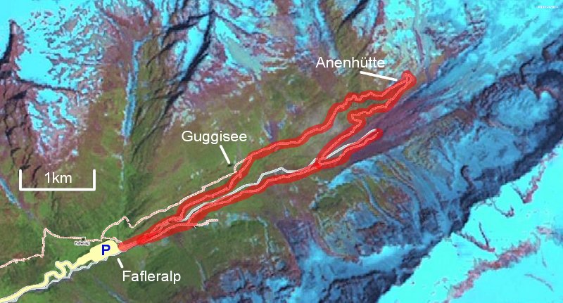
The route from Fafleralp to Anenhütte
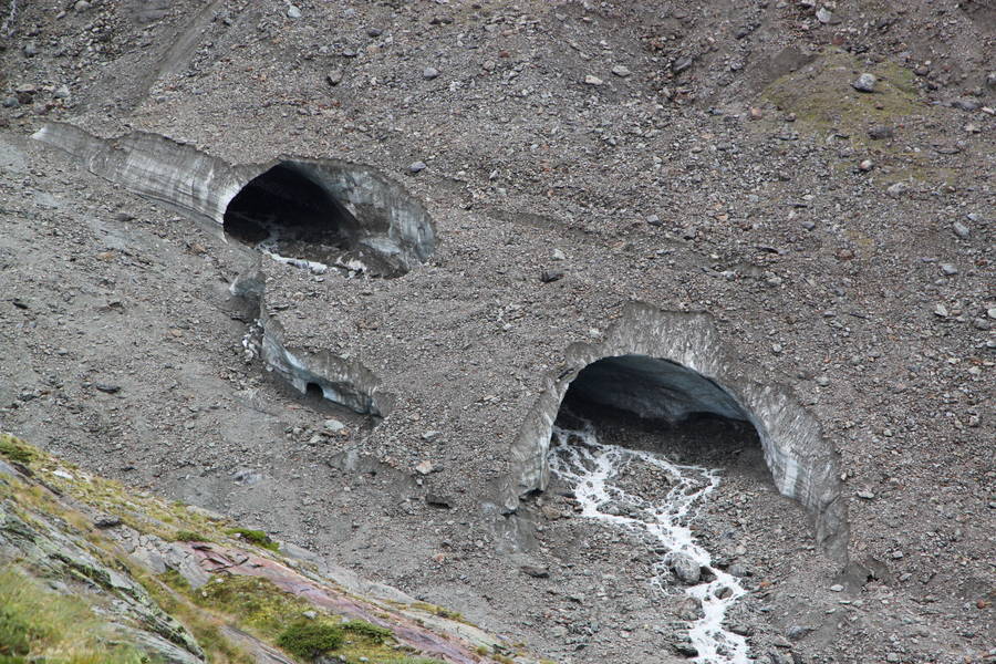
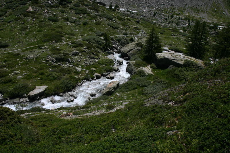
The Langgletscher portals in 2017
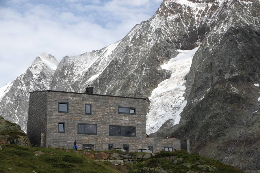
The new Anenhütte opened in 2009
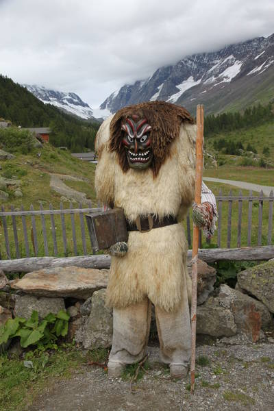
The ogre in Fafleralp carpark
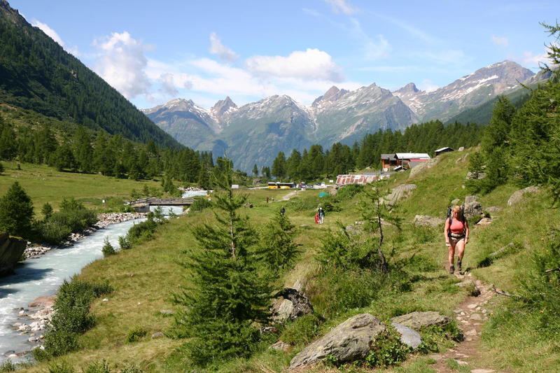
Setting out from Fafleralp car park with the Post Bus in the background
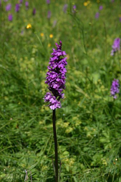
Look out for huge swathes of these alpine orchids on the path alongside the river
The path becomes easier for a time between Guggisee and the bridge over the Anenbach
There are paths either side of the Anenbach stream
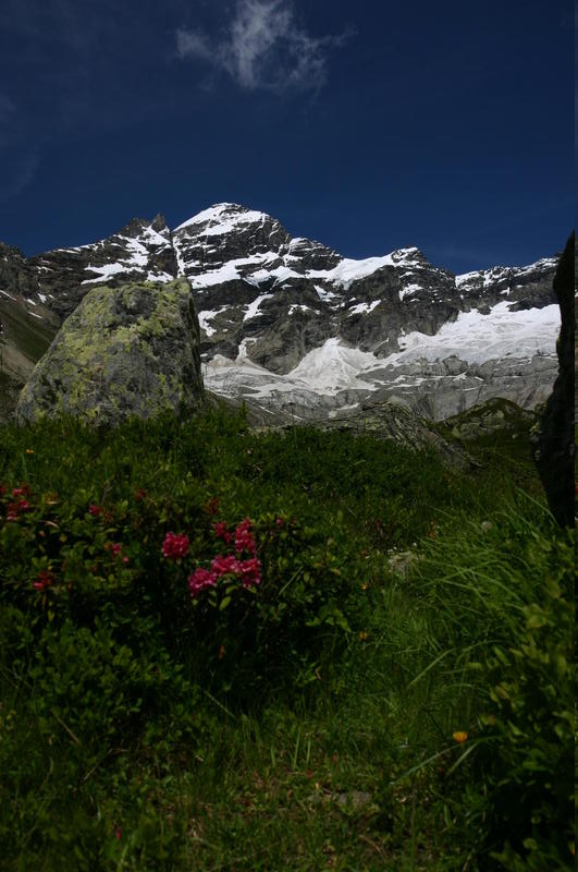
The view to the Lötschen glacier from around Anenhütte
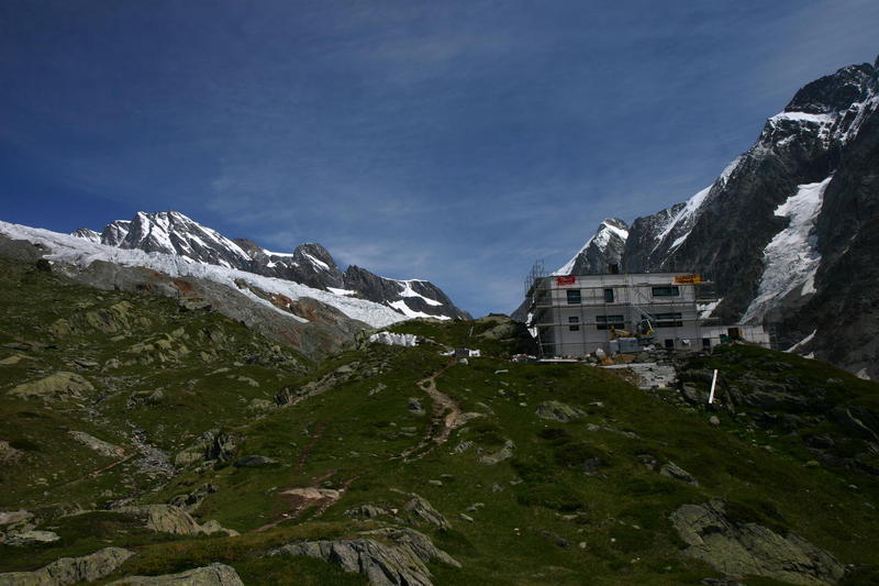
The new Anenhütte under construction in 2008
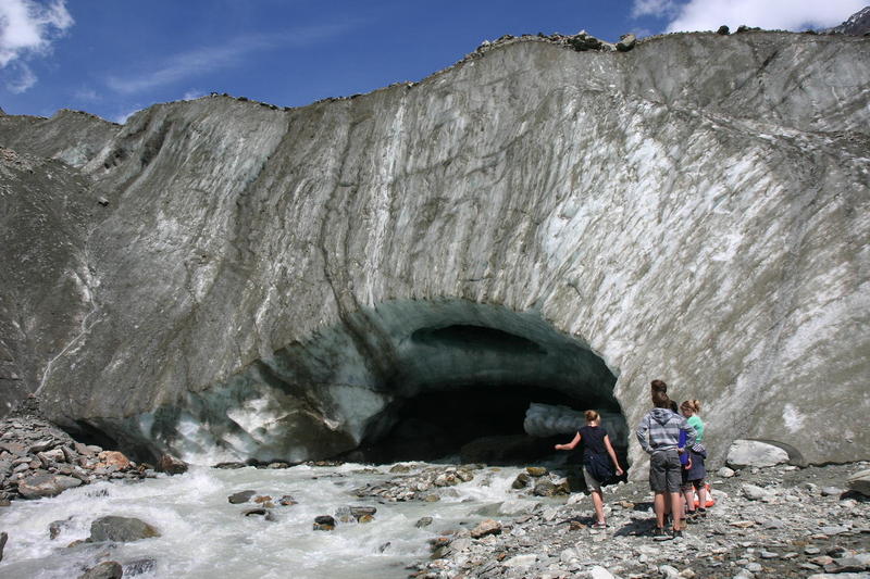
The face of the Langgletscher (circa 2010)
Edit | Attach | Print version | History: r7 < r6 < r5 < r4 | Backlinks | View wiki text | Edit wiki text | More topic actions
Topic revision: r7 - 20 Oct 2017, JaneCurry


- Toolbox
-
 Create New Topic
-
 Index
Index
-
 Search
-
 Changes
-
 Notifications
-
 RSS Feed
-
 Statistics
-
 Preferences
Ideas, requests, problems regarding Walking Wiki? Send feedback