|
|
You are here: Walking Wiki>Walks Web>WalksList>WalkPage39 (09 Oct 2017, JaneCurry)Edit wiki textEdit Attach
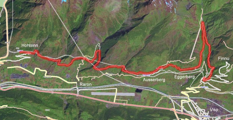
39: Hohenweg Sudrampe - Hohten - Ausserberg - Baldschiedertal - Eggerberg
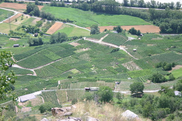
The top half of the Höhenweg Südrampe goes from Hohtenn to Eggerberg. Looking down on the Rhone valley from the Höhenweg Südrampe: This relatively easy route uses the BLS railway to do a one-way walk, returning by train. The railway station at Kandersteg offers a number of tickets such as Kandersteg to Hohtenn, returning from Eggerberg. There are lots of variations along this high-level path (Höhenweg) to either extend or shorten the walk.
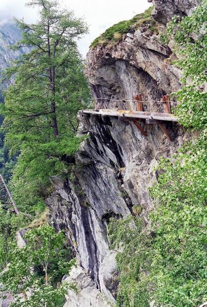
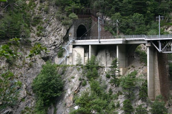
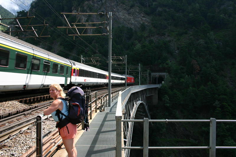
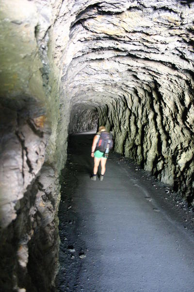
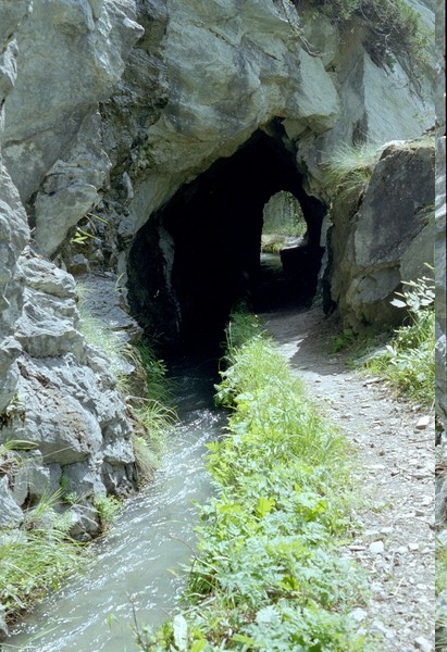
Start from Kandersteg railway station and take the train through to Goppenstein. This is now a stopping train so stay on it through to Hohtenn which is the start of the Höhenweg Südrampe. Go down the road, following signs for the Höhenweg Südrampe BLS - the steep rise after going underneath the railway is probably the steepest part of the whole walk! After a good hour the path arrives at Rarnerkumme where there is a restaurant and good views over the Rhone valley; you are largely following the railway - sometimes above and sometimes below. Continue for at least another half hour to Riedgarten where a number of stone tables and benches might provide an early lunch spot. This section includes the Bietschtal viaduct which you approach through a series of tunnels hewn out of the mountainside; a set of steps takes you up to the level of the railway and the path lies directly alongside the track.
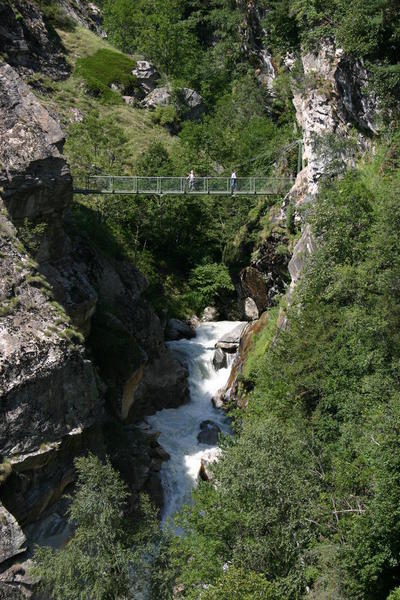
As an alternative on this top part of the track, follow signs to the Hängebrücke 25 minutes out of Hohtenn. This takes you down fairly steeply to join the Lüogjersuon water course which takes you to a suspension bridge across a raging stream. It is about 50 minutes from Hohtenn to the bridge and then 10 minutes from there to rejoin the Höhenweg at Bräaji so the detour will add the best part of an hour, allowing for time at the bridge.
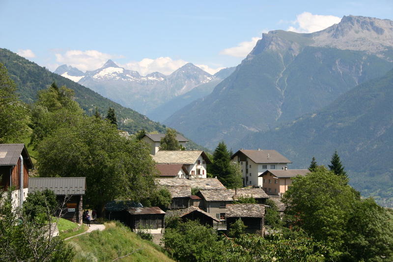
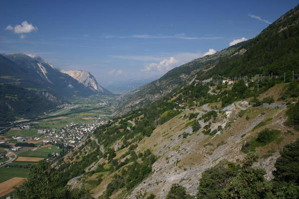
Riedgarten is an excellent vantage point to observe the Rhone valley with its small airfields and alpine villages. From here, it is a bit over an hour to Ausserberg, the first decision point - catch the train home or continue on? Look for the hydrants in Ausserberg: the local children have painted several of them. Ausserberg has a very different atmosphere from Kandersteg; it is a Wallis (Valais) village with many very old chalets. There are several ways through the village but continue to follow the Höhenweg Südrampe BLS signs to leave the village en route for Eggerberg. Another feature of Wallis may become evident as you leave Ausserberg - there is a lot of serious irrigation equipment in the Rhone valley and you can get very wet dodging their powerful water jets! Note that you should not follow signs for Trogdorf unless you are equipped for it: the path from Trogdorf to the Baldschiedertal valley passes through a 1 km tunnel with no lighting.
The Höhenweg takes you to Eggerberg by the shortest route, but a more interesting option is to go up Baldschiedertal following the route of the wasserleitungen ( also known as Suonen) - the water courses built to gather water from mountain streams and channel it to where it is needed. The Baldschiedertal path passes through dappled woodland where you might find alpine strawberries. A signpost marked Pt1099 denotes the next opportunity to cross the river. It is an excellent place to sit beside the rushing water and rest awhile (we have seen at least 3 different bridges here in 20 years!)
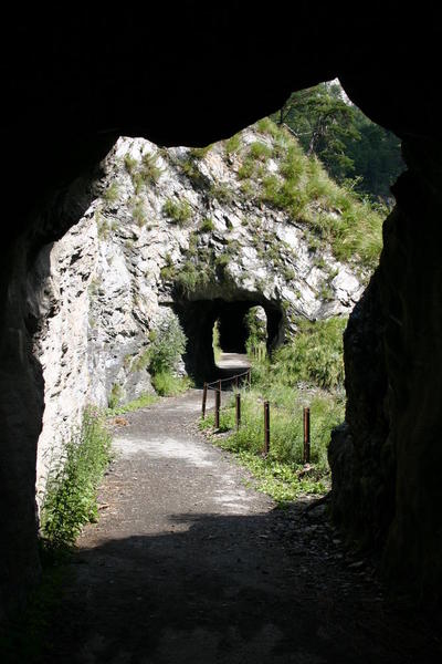
The path now continues on to Eggen passing through another series of tunnels hewn out of the rock (one is just long enough that you have to take about 4 steps in the complete darkness before you see the daylight of the exit!). If you don't like the darkness, one of the tunnels has an "alternative route" - a hollowed tree trunk fastened around the outside of the tunnel with a sheer drop beneath. It is clearly marked "Nur für Schindelfrei!". Wirtschaft Egge provides refreshments as you reach the road just outside Eggen. Make sure you take the green path in Eggen down between the amazing wooden chalets with their profusion of garden flowers and gnomes. From Eggen, it is a steep path down 200m to Eggerberg and the railway station.
It is about 10 km from Hohtenn to Ausserberg, about another 5 km to Pt1099 in Baldschiedertal and about another 5 km back to Eggerberg. The path wanders up and down but there are no long, hard climbs. Hohtenn to Eggerberg is signed as 4 hours 45 minutes if you take the shortest route. Going further up Baldschiedertal will add at least 1 hour and you will probably want extra time to sit beside the bridge over the stream. Make sure you know when the hourly train back to Kandersteg is due at Eggerberg. Be prepared for it to be much hotter on the Höhenweg Südrampe than around Kandersteg and take plenty of water.
This relatively easy route uses the BLS railway to do a one-way walk, returning by train. The railway station at Kandersteg offers a number of tickets such as Kandersteg to Hohtenn, returning from Eggerberg. There are lots of variations along this high-level path (Höhenweg) to either extend or shorten the walk.
Start from Kandersteg railway station and take the train through to Goppenstein. This is now a stopping train so stay on it through to Hohtenn which is the start of the Höhenweg Südrampe. Go down the road, following signs for the Höhenweg Südrampe BLS - the steep rise after going underneath the railway is probably the steepest part of the whole walk! After a good hour the path arrives at Rarnerkumme where there is a restaurant and good views over the Rhone valley; you are largely following the railway - sometimes above and sometimes below. Continue for at least another half hour to Riedgarten where a number of stone tables and benches might provide an early lunch spot. This section includes the Bietschtal viaduct which you approach through a series of tunnels hewn out of the mountainside; a set of steps takes you up to the level of the railway and the path lies directly alongside the track.
As an alternative on this top part of the track, follow signs to the Hängebrücke 25 minutes out of Hohtenn. This takes you down fairly steeply to join the Lüogjersuon water course which takes you to a suspension bridge across a raging stream. It is about 50 minutes from Hohtenn to the bridge and then 10 minutes from there to rejoin the Höhenweg at Bräaji so the detour will add the best part of an hour, allowing for time at the bridge.
Riedgarten is an excellent vantage point to observe the Rhone valley with its small airfields and alpine villages. From here, it is a bit over an hour to Ausserberg, the first decision point - catch the train home or continue on? Look for the hydrants in Ausserberg: the local children have painted several of them. Ausserberg has a very different atmosphere from Kandersteg; it is a Wallis (Valais) village with many very old chalets. There are several ways through the village but continue to follow the Höhenweg Südrampe BLS signs to leave the village en route for Eggerberg. Another feature of Wallis may become evident as you leave Ausserberg - there is a lot of serious irrigation equipment in the Rhone valley and you can get very wet dodging their powerful water jets! Note that you should not follow signs for Trogdorf unless you are equipped for it: the path from Trogdorf to the Baldschiedertal valley passes through a 1 km tunnel with no lighting.
The Höhenweg takes you to Eggerberg by the shortest route, but a more interesting option is to go up Baldschiedertal following the route of the wasserleitungen ( also known as Suonen) - the water courses built to gather water from mountain streams and channel it to where it is needed. The Baldschiedertal path passes through dappled woodland where you might find alpine strawberries. A signpost marked Pt1099 denotes the next opportunity to cross the river. It is an excellent place to sit beside the rushing water and rest awhile (we have seen at least 3 different bridges here in 20 years!)
The path now continues on to Eggen passing through another series of tunnels hewn out of the rock (one is just long enough that you have to take about 4 steps in the complete darkness before you see the daylight of the exit!). If you don't like the darkness, one of the tunnels has an "alternative route" - a hollowed tree trunk fastened around the outside of the tunnel with a sheer drop beneath. It is clearly marked "Nur für Schindelfrei!". Wirtschaft Egge provides refreshments as you reach the road just outside Eggen. Make sure you take the green path in Eggen down between the amazing wooden chalets with their profusion of garden flowers and gnomes. From Eggen, it is a steep path down 200m to Eggerberg and the railway station.
It is about 10 km from Hohtenn to Ausserberg, about another 5 km to Pt1099 in Baldschiedertal and about another 5 km back to Eggerberg. The path wanders up and down but there are no long, hard climbs. Hohtenn to Eggerberg is signed as 4 hours 45 minutes if you take the shortest route. Going further up Baldschiedertal will add at least 1 hour and you will probably want extra time to sit beside the bridge over the stream. Make sure you know when the hourly train back to Kandersteg is due at Eggerberg. Be prepared for it to be much hotter on the Höhenweg Südrampe than around Kandersteg and take plenty of water.

| Time | Height | Location | Comment |
|---|---|---|---|
| 09:55:00 | 1079 | Hohten | |
| 11:00:00 | 1000 | Rarnerkumme | |
| 11:30:00 | 975 | Riedgarten | 10 mins rest |
| 12:35:00 | 960 | Ausserberg Bigstatt | |
| 12:50:00 | 931 | Ausserberg | 25 mins lunch outside Ausserberg |
| 14:45:00 | 1099 | Pt 1099 | |
| 14:50:00 | 1216 | Baldschiedertal bridge | 20 mins rest |
| 15:50:00 | Sign above Eggen | ||
| 16:14:00 | Wirtschaft Egga | ||
| 16:40:00 | 810 | Eggerberg |
Edit | Attach | Print version | History: r7 < r6 < r5 < r4 | Backlinks | View wiki text | Edit wiki text | More topic actions
Topic revision: r7 - 09 Oct 2017, JaneCurry


- Toolbox
-
 Create New Topic
-
 Index
Index
-
 Search
-
 Changes
-
 Notifications
-
 RSS Feed
-
 Statistics
-
 Preferences
Ideas, requests, problems regarding Walking Wiki? Send feedback